

Build Your Own Platform with
CG Intelligence
CG Intelligence is more than just a platform; it’s a customizable gateway to transformative geospatial insights. Designed especially for the data enthusiast and SME business owners in the engineering & consulting sectors, it assures fast deployment with a user-centric approach.
Build & deliver your own:
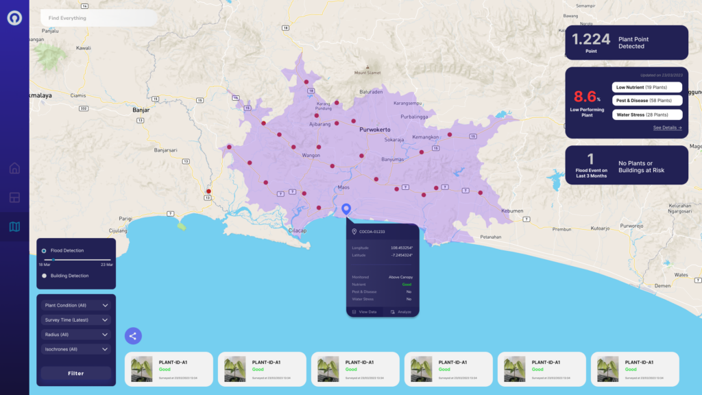
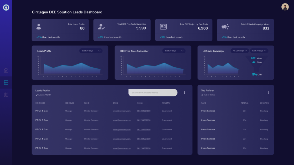
- Location Intelligence
- Hyper-Local Analysis Dashboards
- Interactive Geospatial Storytelling
- Geospatial Portals
- Geospatial Data Warehouses
- Dynamic Risk Mapping
GEO ENABLER: CG Intelligence
How CG Intelligence can Maximize Your Geospatial ROI
Deliver a Cost-Effective Custom Platform
In today’s digital era, businesses need agile solutions that don’t break the bank. CG Intelligence provides a tailored geospatial platform designed with your unique needs in mind. By bypassing the high costs associated with generic, one-size-fits-all systems, we ensure you get the best value for your investment. Our platform emphasizes efficiency and scalability, ensuring you only pay for what you truly need, saving costs in the long run.
Drive Your Data and Insights to Boost Revenue and Growth
Harness the power of CG Intelligence to not only understand your data but also leverage it as a strategic asset. By delivering a tailored geospatial platform to your clients, customers, or other stakeholders, you open up new channels of engagement and value-add services. This, in turn, solidifies your position as an industry leader and trusted partner. As they benefit from the insights and capabilities of your platform, you’ll witness stronger client relationships, increased customer loyalty, and consequently, enhanced revenue streams and business growth. With CG Intelligence, you don’t just interpret data; you turn it into a competitive advantage.
FEATURES
What is included in
CG Intelligence?
Unlock the Comprehensive Features of CG Intelligence: From Advanced Geoprocessing to User-Centric Design
FAQ
FAQs about CG Intelligence
Looking to learn more about CG Intelligence for your business? Browse our FAQs:
CG Intelligence is a customizable platform designed to enhance the delivery and visualization of geospatial data and insights. It offers advanced features, including Big Vector, Big Raster, Route Analysis, and more, tailored for data enthusiasts, engineering & consultants, and SME business owners.
Companies or organizations with data & information, public relations, product, or R&D/developer divisions can benefit the most. It’s particularly suitable for those looking to enhance stakeholder engagement, improve geospatial technology performance, and reduce costs.
CG Intelligence is designed to provide enhanced digital experiences using advanced AI-enabled technology, ensuring cost-effectiveness and promoting a collaborative business approach. Additionally, with the .GIS community version, users can access the platform for free, which has enabled thousands of geospatial community projects.
CG Intelligence supports a wide range of data types, from basic basemaps to more complex data sets like public weather reports, catastrophe history, administration boundaries, and digital elevation models. Custom data requests are also supported.
Our community version, named .GIS, is available for free to support geospatial community projects. Simply check out at https://gis.co.id and follow the instructions.
With features like Big Vector and Big Raster, CG Intelligence is built to handle vast geospatial datasets without compromising on speed or clarity.
Yes, we provide training and support resources. Please send us a message to solution@circlegeo.com